Standing before the weathered stones of an ancient temple or walking through the remains of a once-thriving metropolis creates an extraordinary connection to humanity’s shared past. Archaeological sites represent far more than mere tourist attractions; they function as vast outdoor laboratories where every fragment, inscription, and architectural element contributes to our understanding of how civilisations developed, thrived, and ultimately transformed over millennia. The physical experience of exploring these remnants allows visitors to engage with history in ways that no textbook or digital reconstruction can fully replicate.
When you examine the intricate details of ancient construction techniques, decipher the stories told through material culture, or observe the sophisticated urban planning systems that sustained entire populations, you gain profound insights into human ingenuity and social organisation. These archaeological treasures offer tangible evidence of technological innovation, religious beliefs, economic systems, and cultural practices that shaped the world we inhabit today.
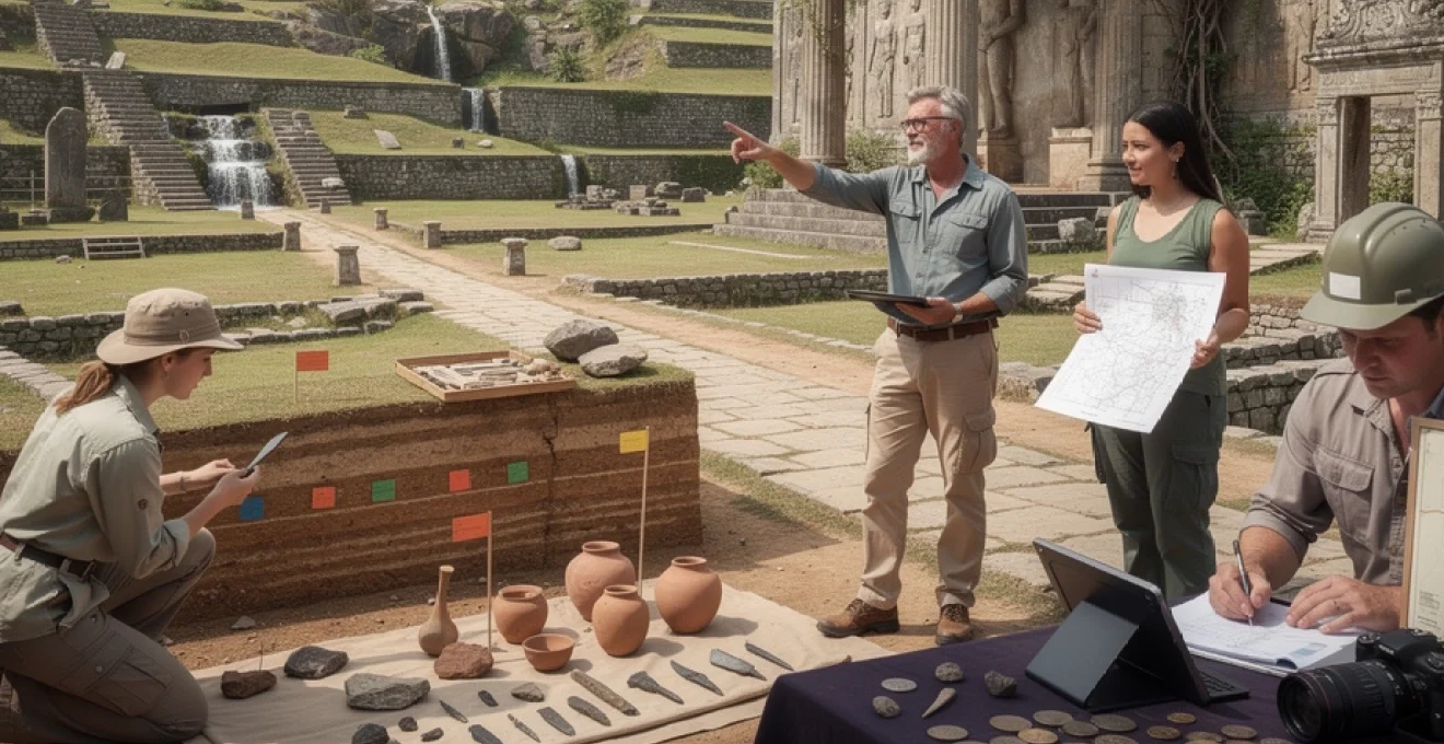
Archaeological stratigraphy and material culture analysis at world heritage sites
The science of archaeological stratigraphy reveals the chronological layers of human occupation through systematic excavation and analysis. Each stratum represents a distinct period in time, containing artifacts, structures, and environmental evidence that illuminate the daily lives of ancient peoples. This methodical approach to understanding the past transforms scattered fragments into coherent narratives about technological development, social change, and cultural continuity.
Material culture analysis examines the physical objects left behind by past societies, from everyday pottery and tools to elaborate ceremonial items and architectural elements. These artifacts serve as silent witnesses to human behaviour, revealing information about manufacturing techniques, trade relationships, religious practices, and social hierarchies. The careful study of material remains enables archaeologists to reconstruct complex pictures of ancient life that extend far beyond what written records might document.
Ceramic typology and dating techniques at pompeii’s villa of papyri
At Pompeii’s Villa of Papyri, ceramic analysis provides remarkable insights into Roman daily life and commercial networks. The villa’s pottery assemblages demonstrate sophisticated classification systems based on vessel forms, decorative techniques, and manufacturing methods. Ceramic typology enables archaeologists to establish precise chronological sequences and identify regional production centres that supplied goods to this luxurious residence.
The preservation conditions at Pompeii allow for extraordinary detail in ceramic studies, with vessels often containing residues that reveal their original contents and usage patterns. Advanced dating techniques, including thermoluminescence and archaeomagnetic dating, provide precise temporal frameworks for understanding the villa’s occupation phases and the broader context of Roman material culture.
Lithic tool analysis from göbekli tepe’s neolithic layers
The lithic assemblages from Göbekli Tepe represent some of humanity’s earliest monumental construction efforts, predating Stonehenge by approximately 6,000 years. Stone tool analysis reveals sophisticated knapping techniques and specialised implements designed for quarrying, carving, and transporting the massive limestone pillars that define this remarkable site. The technological expertise evident in these tools challenges traditional assumptions about Neolithic capabilities and social organisation.
Microscopic use-wear analysis of stone implements provides evidence for specific construction activities and ritual practices. The presence of specialised carving tools suggests organised craft production and potentially dedicated artisan groups, indicating complex social structures that supported such monumental undertakings during the Pre-Pottery Neolithic period.
Architectural chronology through construction techniques at angkor wat
Angkor Wat’s architectural evolution demonstrates the sophisticated engineering capabilities of the Khmer Empire through distinct construction phases spanning several centuries. Analysis of building techniques, stone-cutting methods, and structural innovations reveals technological developments that enabled increasingly ambitious projects. The temple’s precise astronomical alignments and hydraulic engineering systems showcase advanced mathematical and engineering knowledge.
Construction sequence analysis identifies different building campaigns, material sources, and workforce organisation patterns. The integration of architectural elements with landscape modifications, including reservoirs and canal systems, illustrates comprehensive urban planning that supported a population exceeding one million inhabitants at its peak.
Numismatic evidence and trade route reconstruction at ephesus
Coin discoveries at Ephesus provide crucial evidence for reconstructing ancient trade networks and economic relationships across the Mediterranean and beyond. Numismatic analysis
Numismatic analysis allows researchers to track shifts in political control, monetary policy, and commercial intensity by examining coin imagery, inscriptions, and metal composition. Changes in coin hoards found in domestic contexts, harbour districts, and sanctuaries at Ephesus help reconstruct how trade routes evolved from the Hellenistic period through Roman imperial rule. For visitors, standing in the agora where these coins once changed hands turns abstract concepts like “ancient economy” into something tangible: you can literally walk the same commercial streets where merchants counted out denarii and drachmae.
Urban planning and infrastructure systems in ancient civilisations
Beyond individual artifacts, ancient ruins excel at revealing how entire cities were planned, built, and maintained. When you trace the line of a buried water channel or follow the grid of stone-paved streets, you are reading an ancient blueprint for urban life. Archaeological sites preserve physical evidence of zoning, transportation, sanitation, and defence systems that show how different civilisations solved perennial challenges of crowding, resource distribution, and public order.
Studying urban planning in situ offers a deeper understanding of civilisations than maps or diagrams alone. You notice how temples dominate certain vistas, how marketplaces cluster near city gates, and how elite residences occupy elevated or better-drained ground. These spatial patterns speak volumes about power, inequality, and everyday experience, turning ancient cities from abstract names into lived environments you can navigate and interpret for yourself.
Hydraulic engineering at machu picchu’s agricultural terraces
Machu Picchu’s dramatic setting often steals the spotlight, but its sophisticated hydraulic engineering is what made permanent occupation possible. The Inca devised an intricate system of canals, fountains, and drainage galleries that channelled mountain springs through the citadel while preventing catastrophic erosion. When you walk beside these still-functioning channels, you see how carefully graded slopes and stone-lined conduits controlled the movement of water across terraced agricultural landscapes.
The agricultural terraces themselves are feats of layered engineering, with permeable stone walls, gravel sub-layers, and topsoil that together manage moisture and stabilise steep hillsides. Archaeological soil analysis shows that some terrace soils were imported from lower valleys, indicating deliberate optimisation of crop production at high altitude. Experiencing this water management system on site helps you appreciate how deeply Inca society integrated engineering, agriculture, and sacred landscape into a single coherent worldview.
Road network design and mile markers along hadrian’s wall
Along Hadrian’s Wall in northern Britain, the remains of Roman roads and milecastles reveal a military infrastructure that was as much about logistics as defence. The Romans designed straight, cambered roads with layered foundations of stone and gravel, allowing legions, supplies, and messages to move efficiently across often boggy terrain. Surviving mile markers and inscriptions along these routes record distances, emperors, and construction units, providing a kind of ancient project management record carved in stone.
Walking stretches of these roads today, you experience the deliberate regularity that characterised Roman frontier planning. Forts, signal towers, and civilian settlements cluster at predictable intervals, reflecting a calculated balance between surveillance, supply, and local integration. This physical encounter with the Roman transport network makes it easier to grasp how an empire spanning three continents held itself together through standardised engineering and relentless attention to connectivity.
Drainage and sewerage systems in indus valley harappa
The ruins of Harappa and other Indus Valley sites demonstrate that effective urban sanitation is not a modern invention. Excavations reveal covered brick drains running beneath streets, household bathing platforms connected to waste channels, and soak pits designed to filter grey water. The uniformity and scale of these drainage systems suggest that civic hygiene was a core concern of Indus urban planners, long before written treatises on public health.
When you stand above these ancient sewers, often still neatly lined with carefully fitted bricks, you see how infrastructure underpinned daily life in ways that written records from other cultures rarely mention. The absence of monumental palaces but presence of extensive sanitation hints at a social system that prioritised collective urban wellbeing. For modern visitors, Harappa’s infrastructure raises provocative questions: what do our own cities choose to monumentalise, and what do we quietly bury out of sight?
Defensive architecture and siege warfare evidence at mycenae
Mycenae’s imposing cyclopean walls and fortified gates are among the most vivid physical expressions of Bronze Age power and insecurity. The sheer size of the boulders, stacked without mortar, creates an impression of overwhelming strength that ancient Greeks themselves attributed to mythical giants. Yet close inspection of wall angles, gate design, and auxiliary structures reveals a calculated response to specific military threats, from battering rams to escalade attempts.
Archaeological evidence of arrowheads, sling stones, and fire damage in certain layers suggests episodes of siege warfare, allowing researchers to reconstruct attack and defence tactics. Features such as the narrow Lion Gate, with flanking bastions and a steep approach, forced attackers into confined, vulnerable positions. As you climb these slopes and pass through these choke points today, you can almost feel how defenders would have controlled movement and sightlines, turning architecture into a three-dimensional manual on ancient conflict.
Religious and ceremonial architecture revealing societal hierarchies
Religious and ceremonial buildings at ancient ruins are often the most visually striking structures, but their real significance lies in how they encode social relationships. Temple platforms, processional ways, altars, and shrines were not just places of worship; they orchestrated movement, visibility, and access in ways that reinforced who held power and who did not. By paying attention to staircases, thresholds, and sightlines, you can read these spaces as spatial diagrams of hierarchy.
Consider how access restrictions worked in many temple complexes. Outer courtyards welcomed large crowds, while inner sanctuaries remained accessible only to priests or royalty. Elevated platforms made rulers and deities literally higher than common worshippers, while axial processional routes choreographed festivals that brought elites into public view at carefully chosen moments. Walking these same routes today lets you experience how architecture guided bodies and shaped belief, making abstract power relations visible in stone.
In Mesoamerican cities such as Teotihuacan, towering pyramids and broad ceremonial avenues organised the entire urban layout around ritual activity. In Egypt, temple complexes like Karnak expanded over centuries as successive pharaohs added pylons and courtyards, each extension a physical assertion of divine kingship. Observing construction sequences, altered entrances, or walled-off areas helps archaeologists track shifting religious emphases and political realignments, and visitors can sense these changes in how different parts of a complex feel open, constrained, or monumental.
Epigraphic studies and ancient writing systems decipherment
Inscriptions carved into stone, painted on plaster, or incised on pottery transform ruins from mute remains into speaking landscapes. Epigraphic studies focus on documenting, reading, and interpreting these texts, which range from royal proclamations and legal codes to casual graffiti left by ordinary visitors. Deciphering ancient writing systems has often been the key that unlocked entire civilisations, turning ruins into readable archives.
At sites like Egypt’s temples at Philae or Luxor, bilingual and trilingual inscriptions, such as the famous Rosetta Stone (now in the British Museum but originally from a temple context), provided the comparative material needed to break long-lost scripts. Similarly, the discovery of the Behistun Inscription in Iran, carved high into a cliff face, was crucial for understanding cuneiform. Visiting such places, even when the original artifacts have been moved, gives a visceral sense of the scale and ambition behind these carved declarations meant to impress both humans and gods.
Beyond grand monuments, more modest inscriptions at ancient ruins often provide the most intimate glimpses of past lives. At Pompeii, election notices, shop signs, and even humorous graffiti record the voices of individuals otherwise absent from elite historical narratives. In the Maya region, stelae and temple inscriptions combine calendrical data, dynastic histories, and mythic events, allowing modern scholars to reconstruct political chronology and ritual cycles. Standing before these carved texts, you confront the dual challenge and allure of ancient literacy: much has been decoded, yet much remains tantalisingly opaque.
Comparative mortuary practices and social stratification evidence
Burial grounds and tombs surrounding many archaeological sites provide some of the clearest evidence for how ancient societies understood death, ancestry, and inequality. Mortuary practices leave behind durable traces: grave goods, body positions, tomb architecture, and cemetery layouts all encode information about social status, gender roles, and religious beliefs. When you walk through ancient necropolises, you are effectively entering an archive of social structure written in stone and soil.
Comparing simple pit burials with elaborate chamber tombs, for example, often reveals pronounced social stratification. In Mycenae, richly furnished shaft graves containing gold masks, weapons, and imported luxury items contrast sharply with more modest burials, illustrating an elite class with far-reaching trade connections. In contrast, some Neolithic communal tombs in Atlantic Europe emphasise collective ancestry over individual distinction, suggesting different conceptions of identity and memory.
Bioarchaeological analysis of human remains adds another layer of insight, identifying markers of nutritional stress, occupational injuries, or violent trauma. These data help us understand who bore the physical burdens of labour, who enjoyed better diets, and how warfare or epidemic disease affected different segments of the population. As a visitor, noticing the spatial relationship between living areas and cemeteries—whether tombs crowd city edges, lie beyond ritual boundaries, or integrate into domestic spaces—can deepen your sense of how ancient people negotiated the boundary between the worlds of the living and the dead.
Conservation challenges and digital documentation technologies at archaeological sites
Visiting ancient ruins today also means encountering them at a critical moment in their long histories. Many sites face accelerating threats from climate change, urban expansion, looting, and mass tourism. Rising sea levels imperil coastal structures, increased rainfall and temperature fluctuations undermine masonry, and visitor traffic erodes fragile surfaces. Understanding these conservation challenges gives you a deeper appreciation of how precarious our connection to the distant past can be.
Archaeologists and conservators are responding with a combination of traditional techniques and cutting-edge digital tools. High-resolution 3D laser scanning, photogrammetry, and drone surveys create precise digital twins of monuments and landscapes, preserving their current condition in remarkable detail. These models support structural analysis, guide restoration decisions, and allow virtual access for those unable to visit in person. In some cases, such as threatened rock art shelters or collapsing temple facades, digital documentation may be the only enduring record if the physical structure is lost.
For you as a visitor, being mindful of site guidelines—staying on marked paths, avoiding physical contact with fragile carvings, and respecting restricted areas—is a simple but vital way to support long-term preservation. Many heritage sites now offer augmented reality apps or on-site digital displays that overlay reconstructions onto present-day ruins, helping you imagine original appearances without rebuilding or over-restoring the remains. This balance between access and protection mirrors a broader question at the heart of heritage management: how can we share the experience of ancient ruins widely while ensuring that future generations can still stand where we stand and feel the same powerful connection to vanished civilisations?