The allure of a pristine, uncrowded beach has become increasingly elusive in our hyper-connected world. As popular coastal destinations buckle under the weight of mass tourism, discerning travellers seek alternative approaches to finding genuine solitude by the sea. The challenge lies not in the scarcity of hidden beaches—thousands exist along coastlines worldwide—but rather in developing the research skills, local intelligence networks, and strategic planning required to locate them. Whether you’re pursuing wild swimming in remote coves, searching for undiscovered surf breaks, or simply craving a Robinson Crusoe experience away from beach umbrellas and ice cream vendors, the methodology for discovering secluded coastal gems has evolved dramatically. Advanced cartographic tools, crowd-sourced intelligence, and a deeper understanding of coastal access rights have democratised beach exploration in ways unimaginable just a decade ago.
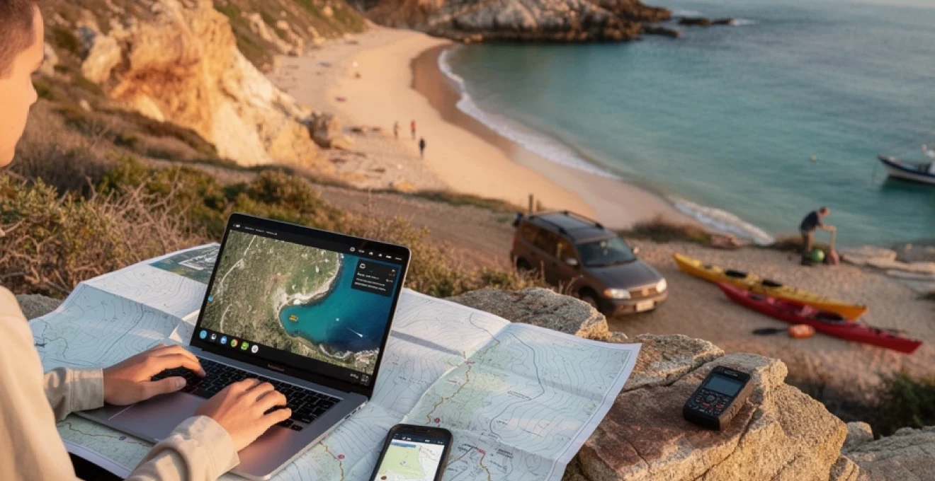
Leveraging satellite imagery and cartographic tools to identify hidden coastal locations
Modern technology has revolutionised the way adventurous beachgoers identify secluded shorelines. Satellite imagery platforms offer unprecedented access to coastal reconnaissance, enabling you to survey thousands of miles of coastline from your laptop before ever setting foot on sand. The strategic application of these digital tools can reveal beaches that remain invisible to conventional tourism marketing channels.
Using google earth pro’s historical imagery to track coastal development patterns
Google Earth Pro provides a powerful historical timeline feature that allows you to observe coastal development patterns over decades. By sliding the historical imagery timeline backwards, you can identify beaches that were once isolated but have since been discovered, as well as those that remain remarkably unchanged. This temporal analysis reveals crucial patterns: beaches with minimal infrastructure development over a 10-15 year period typically indicate either protected status, difficult access, or simply successful obscurity. When examining satellite imagery, focus on beaches lacking the telltale signs of tourism infrastructure—car parks, coastal roads, or visible buildings within 500 metres of the shoreline. The absence of these features often correlates with reduced visitor numbers and enhanced solitude.
Analysing topographic maps and bathymetric charts for inaccessible shorelines
Topographic maps reveal the physical barriers that keep beaches secluded. Steep contour lines indicating cliffs, dense vegetation symbols, or the absence of marked trails all suggest limited accessibility—and therefore limited crowds. Bathymetric charts, traditionally used by mariners, provide equally valuable intelligence for beach hunters. Offshore reefs, shallow bars, and rocky underwater terrain visible on these charts indicate beaches that may be unsuitable for large-scale boat access but perfect for kayakers or those willing to scramble along coastal paths. The combination of steep coastal topography and challenging offshore conditions creates natural filters that deter casual beachgoers whilst attracting adventurous souls seeking authentic coastal wilderness.
Exploring coastal access points through OpenStreetMap and gaia GPS data
OpenStreetMap (OSM) offers crowd-sourced cartographic data that frequently includes footpaths, unofficial trails, and access points absent from commercial mapping services. The platform’s granular detail often reveals narrow coastal paths, farm tracks leading to shorelines, or historic rights of way that provide legal access to otherwise isolated beaches. Gaia GPS integrates multiple map layers—including topographic, satellite, and trail data—creating a comprehensive planning tool for coastal exploration. By overlaying different datasets, you can identify the intersection of accessible routes and secluded beaches. Look specifically for beaches with only footpath access, as the 15-20 minute walk required to reach them dramatically reduces visitor numbers compared to beaches with adjacent parking facilities.
Identifying private beach easements and public Right-of-Way corridors
Understanding coastal access rights represents one of the most valuable yet overlooked aspects of beach discovery. In the United Kingdom, for instance, the Coastal Access programme has created a continuous path around England’s coastline, providing legal access to numerous previously difficult-to-reach beaches. Similar public trust doctrines exist in various jurisdictions worldwide, guaranteeing access to intertidal zones even when adjacent land remains private. Researching local cadastral maps and land registry data can reveal public easements that provide legitimate access to apparently private shorelines. In Cornwall, for example, numerous stunning coves remain lightly visited despite public access simply because the narrow footpaths leading to them
simply pass unnoticed at the end of farm lanes or between clusters of cottages. The key is to combine legal awareness with on-the-ground discretion: always respect signage, close gates behind you, and avoid crossing obviously occupied private gardens, even where the intertidal zone itself is public.
Crowd-sourced intelligence: mining local knowledge from regional forums and fishing communities
Digital maps are powerful, but there is no substitute for human knowledge when you are trying to discover truly secluded beaches away from the tourist crowds. Locals, especially those who work on or near the sea, have a mental map of coves, launch points, and quiet strands that never appear in glossy brochures. By tapping into regional communities—both online and offline—you can dramatically shorten the learning curve and avoid wasting time on overexposed “hidden” spots.
Navigating regional subreddits and facebook groups for insider beach recommendations
Regional forums—particularly subreddits and Facebook Groups—act as living guidebooks, constantly updated with trip reports, photos, and access updates. Subreddits like r/Cornwall, r/Scotland, or destination-specific travel boards often feature threads on quiet beaches, access paths, and parking hacks. When you join these communities, spend time reading older posts before asking questions; this not only helps you avoid repeating common queries, but also reveals patterns about which coves stay empty in high season and which are already on the mainstream radar.
Facebook Groups focused on wild swimming, coastal hiking, or regional photography can be equally valuable. To get useful responses, frame your questions with care: instead of asking for “secret beaches” in general, explain that you are looking for less crowded beaches, are happy to walk 30–40 minutes, and are committed to Leave No Trace ethics. People are far more willing to share sensitive locations when they trust you will not broadcast them to thousands on social media. Consider keeping detailed coordinates or route information in a private log, rather than reposting them publicly.
Consulting with local fishermen and boat charter operators for Off-Grid coves
Harbours, fish markets, and small marinas are goldmines of coastal intelligence. Local fishermen, shellfish harvesters, and small-boat skippers know where anchorages are quiet, which beaches are only accessible by sea, and which headlands shelter calm water on specific wind directions. Approach these conversations with humility and curiosity: buy a coffee or a drink, ask about safe landing spots and tides, and be upfront about your experience level. You are far more likely to get honest advice—and perhaps a few coordinates—if you demonstrate respect for the sea and an understanding of basic seamanship.
Boat charter operators, sea-kayak guides, and sailing schools can also point you towards off-grid coves, especially if you book a trip or course with them. Instead of asking bluntly for their “secret spots,” enquire about itineraries that focus on quiet bays, wildlife watching, or wild swimming. Often, they will design routes that avoid crowded anchorages and drop you near remote beaches for lunch or a swim. Over time, you can build a mental chart of these locations, noting which ones you might safely revisit under your own power by kayak or on foot.
Cross-referencing surfing forums like the inertia and surfline for Lesser-Known breaks
Surfing communities have been quietly mapping hidden beaches and reef breaks for decades, long before digital nomads made “secret beach” a hashtag. Forums and editorial platforms such as The Inertia, Surfline, Magicseaweed archives, or region-specific surf message boards often mention lesser-known breaks that require a hike in or a careful read of the tides. Even if you are not a surfer, these resources can highlight stretches of coastline where car access is limited and the main visitors are dedicated wave-hunters rather than day-trippers.
To use surf intel effectively, treat it like decoding a weather chart rather than reading a simple list. When someone mentions a break that “only works on a big north swell and mid-tide with light offshore winds,” that often implies the beach is quiet in many other conditions—potentially ideal if you just want solitude and sea air. Cross-reference break locations with satellite imagery and topographic maps: if the only approach appears to be a faint footpath or cliff scramble, that is a strong indicator that the bay remains under the radar for most tourists. Just remember that surf etiquette is strict; if you do enter the water at a little-known break, do so respectfully, follow local customs, and avoid geotagging shots that might blow up a fragile spot.
Strategic timing and seasonality analysis for optimal beach solitude
Even the most famous coastlines have quiet moments. Often, the difference between a beach packed with parasols and a nearly empty arc of sand is not the location itself but when you choose to visit. By analysing seasonality, tourism flows, and natural rhythms such as tides and swell, you can transform well-known coastal regions into your own network of secluded beaches away from the tourist crowds.
Utilising shoulder season windows in mediterranean and caribbean destinations
Tourist numbers in popular regions like the Mediterranean and Caribbean are highly seasonal. In many Mediterranean countries, visitor arrivals in July and August can be more than double those in May or October. By targeting shoulder seasons—late spring and early autumn—you benefit from warm water, milder air temperatures, and dramatically quieter beaches. In Greece, for example, early June and late September often offer ideal conditions: ferries still run frequently, but many package holidaymakers have not yet arrived or have already left.
In the Caribbean, seasonality is influenced both by northern hemisphere holiday calendars and by hurricane risk. If you are prepared to accept slightly higher rainfall probabilities and keep a close eye on forecasts, late April–early June and November–early December can deliver near-empty beaches and reduced accommodation rates. Think of it as threading a needle between peak-season crowds and the most active storm periods. Tools such as tourism statistics websites, Google Travel’s “popular times” data, and even historical flight price charts can help you pinpoint these quieter windows with surprising precision.
Exploiting tidal cycles and moon phases for temporarily accessible beaches
Some of the most magical secluded beaches in the world are not hidden at all—they are simply underwater most of the time. Tidal islands, sandbars, and rock-fringed coves can appear like mirages for a few hours each day, only to vanish again as the tide rises. To safely take advantage of these temporary escapes, you need to understand local tide tables and how they interact with moon phases. Spring tides, which occur around new and full moons, bring greater tidal ranges, often exposing wider beaches and connecting islands to the mainland via causeways of sand or rock.
Planning to visit such locations is a little like catching a train: you need to know exactly when the “platform” will appear and how long you can stay before your route home is cut off. Many coastal rescue organisations report annual spikes in callouts for stranded walkers who misjudged these windows. To avoid joining their statistics, always build in a generous safety margin—aim to arrive at a tidal-access beach at least an hour before low tide and leave well before the flood returns. Smartphone tide apps, harbour authority websites, and nautical almanacs can give you precise data; combine this with local advice, and you can access stretches of sand seen by very few people.
Monitoring weather patterns and swell forecasts through windy.com and PredictWind
Weather and ocean conditions play a decisive role in how crowded a beach feels. Strong onshore winds, choppy surf, or overcast skies will deter casual sunseekers, leaving the coast to more committed explorers. Platforms like Windy.com, PredictWind, and regional meteorological services allow you to visualise wind direction, swell height, cloud cover, and even fog likelihood days in advance. By identifying days when conditions are marginal for sunbathing but still safe and enjoyable for walking or wild swimming, you can cherry-pick times when even popular stretches of coast are half-empty.
For example, if a prevailing wind makes one side of a peninsula rough and exposed, the opposite shore may be sheltered and calm. Reading a wind map is like rotating a compass in your mind: a strong northwesterly might make west-facing surf beaches unpleasant, while south-facing coves remain quietly idyllic. Similarly, low-visibility days often see a sharp drop in visitor numbers. As long as you are comfortable navigating in mist and rain, a grey forecast can become your ally in securing beach solitude, especially in regions where fair-weather crowds dominate.
Remote archipelagos and coastal wilderness areas with minimal tourism infrastructure
Some of the best chances for genuine isolation lie in places where tourism infrastructure is deliberately limited or logistically difficult to build. Remote archipelagos, marine reserves, and sparsely populated coastal regions often feature kilometres of shoreline with no permanent settlements at all. Think of Scotland’s Outer Hebrides, Norway’s Lofoten Islands, Canada’s Pacific Rim National Park, or lesser-known island chains in the Aegean and Caribbean. What these destinations share is a combination of access complexity, strict environmental regulations, and limited accommodation capacity.
To make the most of such regions, you need to embrace a more expedition-style mindset. Transport connections may involve multiple ferries or small domestic flights, provisions might be basic, and weather can be unpredictable even in summer. Yet the rewards can be extraordinary: entire arcs of white sand where your only company is seabirds, seals, or the distant splash of dolphins. When researching, search not only for “best beaches” but for terms like “coastal wilderness,” “marine protected area,” or “no road access.” Trip reports from sea kayakers, long-distance hikers, and yacht crews often highlight bays that remain invisible to mainstream travel media. Just remember that minimal infrastructure also means minimal rescue capability—self-reliance, proper gear, and conservative decision-making are essential.
Accessing secluded beaches via alternative transportation: kayaking, hiking, and 4WD routes
One of the most effective ways to discover secluded beaches away from the tourist crowds is to choose modes of transport that most visitors overlook. If 90% of people stick to beaches with car parks, then beaches that require a paddle, a long hike, or a careful drive down a sand track naturally filter out the masses. Alternative access is not just about novelty; it is a practical strategy for reaching coves that remain quiet even at the height of summer.
Planning Multi-Day coastal kayak expeditions to uninhabited islands
Sea kayaking opens up an entirely different layer of coastline—sea caves, pocket beaches, and skerries that are unreachable or unsafe to approach from land. Planning a multi-day coastal kayak trip to uninhabited islands or sparsely populated peninsulas can feel like designing your own miniature expedition. Start with sheltered regions known for stable summer conditions and short crossings between landmasses; national park websites, guidebooks, and local outfitters are invaluable for identifying beginner-friendly itineraries.
Safety should shape every aspect of your planning. Check charts for landing spots that are sheltered from prevailing winds and swell, build contingency days into your schedule in case a front rolls through, and carry redundant navigation systems (paper chart plus waterproof GPS or mapping app). Overnight wild camping, where permitted, demands a strict Leave No Trace approach: camp above the high-tide line, avoid fragile dune systems, and pack out everything you bring in. The payoff for this effort is immense—waking up to sunrise over an empty bay and launching directly from your tent into glassy water is an experience mass tourism can never replicate.
Identifying unmarked trailheads and scramble routes using AllTrails pro filters
Hiking is often the most reliable way to turn a busy coastline into a string of secluded beaches. Apps like AllTrails Pro, Komoot, and regional walking databases allow you to filter for coastal routes, elevation gain, and trail popularity. By focusing on paths marked as “moderate” or “difficult” with lower user counts, you can often find descents to coves that casual walkers ignore. In many cases, the trail to the beach is not the official destination at all but a short spur from a longer coastal route—an unpromoted junction used mainly by locals and regular walkers.
When interpreting route descriptions, look for subtle clues: mentions of “steep sections,” “scramble required,” or “not suitable for children” all suggest a natural crowd filter. Satellite imagery can then help you confirm where these paths meet the shoreline. It is crucial, however, to respect erosion-prone slopes and cliff edges; never invent new shortcuts or follow faint goat tracks that lead into unstable terrain. Treat each descent like a mini alpine route: check ground conditions, be prepared to turn back, and always consider how you will get back up if the tide or weather shifts.
Navigating sand tracks and beach access roads with offline GPS applications
In some regions—particularly Australia, New Zealand, South Africa, and parts of the Americas—remote beaches are accessed via unsealed roads, forestry tracks, or soft sand that standard rental cars cannot safely handle. Here, 4WD vehicles and offline GPS apps such as Gaia GPS, Maps.me, or dedicated off-road navigation tools become essential. Before you venture onto any unpaved route, research its current status via local forums, park rangers, or recent trip reports; storms, fires, or logging operations can change conditions quickly.
Driving on sand and rough tracks requires a different skill set than motorway cruising. Lower tyre pressures, controlled momentum, and an understanding of where you can safely turn around all help prevent the classic scenario of being bogged down at high tide. Think of your vehicle as another form of expedition gear: capable, but limited by your own knowledge and the environment. Always carry recovery equipment, water, and enough supplies to wait out a tide cycle if necessary. Many of the quietest beaches accessed this way are popular only with fishermen and serious off-roaders, which means that even during holiday periods you may share miles of sand with just a handful of other vehicles.
Securing permits for protected coastal reserves and national park backcountry areas
Some of the most pristine secluded beaches fall within protected areas that intentionally restrict visitor numbers through permit systems. Far from being a bureaucratic obstacle, these permits can be your ticket to solitude. National parks in countries such as the United States, Australia, New Zealand, and South Africa often operate quota systems for backcountry coastal campsites, overnight kayak routes, or multi-day hikes. By planning several months in advance and being flexible with your dates, you can secure access to stretches of coastline where daily visitor numbers are capped in the dozens rather than the thousands.
When applying for permits, think like a strategist. Midweek dates, outside local school holidays, and shoulder seasons typically see lower demand. Some systems release cancellations or additional quotas at set times, much like popular trekking routes or wilderness rivers; setting reminders and checking regularly can pay off. Permits usually come with conditions—designated camping zones, fire bans, mandatory bear canisters in some regions—which exist to protect fragile ecosystems. By embracing these rules rather than resenting them, you help ensure that those hidden beaches remain wild and undeveloped for years to come.
Ethical considerations: leave no trace principles and respecting coastal ecosystems
Finding a secluded beach is only half the story; how you behave once you arrive determines whether that place will remain special for future visitors and local wildlife. Coastal ecosystems are among the most sensitive on Earth. Dunes stabilise entire shorelines, nesting birds rely on undisturbed sand, and intertidal rock pools host complex micro-worlds that can be destroyed with a single careless step. As explorers of these quieter places, we carry a responsibility that goes beyond simply tidying up after ourselves.
Applying Leave No Trace principles to the coast means more than packing out rubbish. It includes choosing durable surfaces for walking and camping, avoiding trampling dune grass, keeping fires well above the high-tide line (or avoiding them entirely where prohibited), and minimising noise in areas where animals rest or breed. If you are tempted to share a new discovery online, ask yourself: will geotagging this exact location help protect it, or will it funnel hundreds of new visitors to a fragile cove with no toilets, bins, or paths? In many cases, it is more ethical to describe your experience in general terms—perhaps naming a broader region rather than a precise bay—so that only those willing to invest real research effort will find it.
Respecting local communities is equally important. Many secluded beaches border working farmland, indigenous territories, or small fishing settlements. Observe local access customs, keep noise and lights down at night, and support nearby economies by buying from village shops, cafés, or guides. Ultimately, discovering secluded beaches away from the tourist crowds is not about staking a private claim to a piece of coastline. It is about developing the skills and ethics to move lightly through wild places—leaving only faint footprints in the sand and taking home memories, not souvenirs.